Multiscalar Spaces: Deep Mapping the Lake District with Literary GIS
The Lab
Level 2 of the Digital Studio
West Wing of Arts West
(access via the rear lift)
More Information
Dr Joanna Taylor (@JoTayl0r0)
University of Manchester
For many scholars in literary studies, GIS continue to seem antithetical to the nuanced close reading of individual texts that characterises the discipline. A danger with using GIS to read the spatial data provided by written texts is that they reduce the significance of the individual text in preference for the large corpora, or that they privilege distant reading over close.
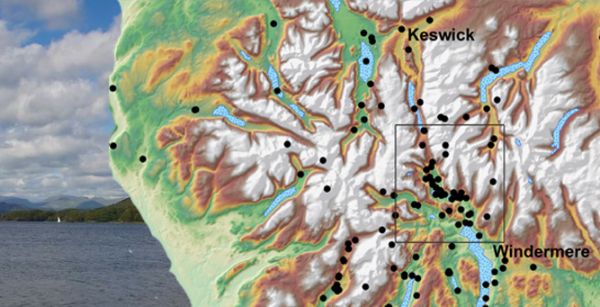
Reporting on the Leverhulme Trust-funded project 'Geospatial Innovation in the Digital Humanities: A Deep Map of the English Lake District' (2015-18), this seminar will examine how GIS might be used, to adapt Matthew Jockers's term, for microanalysis. It will offer an overview of the challenges faced in using GIS for literary study, and explore how the 'Geospatial Innovation' project combated some of these issues. The seminar will suggest that a literary approach to mappable data might help uncover experiential meaning in digital projects in ways that situate humanists more centrally in a digital world.
Dr Joanna Taylor is Presidential Academic Fellow in Digital Humanities at the University of Manchester. Her current research focuses on environmental and digital humanities, and specifically how digital cartographies can intersect with close readings of historical landscape literature to inform modern environmental perceptions and practices.
Image: Geospatial Innovation project, Lancaster University and Leverhulme Trust